Search the Community
Showing results for tags 'map'.
-
Sources posted below. In 1993, Kentucky's primary crop was tobacco. Its secondary crops were beef & dairy. Knox County itself had three types of commodities in 1988: tobacco, beef, and dairy. By 1993 the dairy farmers had stopped exporting. Jefferson County itself was almost 100% tobacco by 1993, along with nearby counties. It would be nice if these tobacco & beef farmers were represented ingame instead of having corn everywhere. There are a few major advantages to doing this: 1) It increases difficulty. Tobacco is not exactly edible like corn is. 2) Tobacco would not be easily converted into cigarettes. In Kentucky, most farmers cut & cured the tobacco themselves. They would harvest it, chop it into the valuable parts, hang it in a barn to dry, then take it all to an auction warehouse to be sold. 3) Tobacco farming has its own tools. These tools are generally (besides the machete) not very useful for combat. 4) Beef cattle could work well with the new animal system coming up. These cattle would may have some zombie problems and/or starve and/or freeze and/or become a tasty snack and/or use their fierce hooves & horns to maul a player since the whole Zombie Apocalypse thing may make cattle less friendly toward humanity.... 5) Beef cattle do not produce much milk, making them less useful. Moreover, short of players having freezers set up or curing methods set up, a lot of their meat could go to waste. 6) It would enable you to make very spooky barns. Whether they're dark slaughterhouses full of dead cattle from a zombie that snuck in before panicked cattle broke down the doors & ran, or hard to see rooms full of hanging tobacco leaves a zombie could be lurking in to ambush the player, there's lots of options! It would also help with the players asking for tobacco seeds. Kentucky historically HAD lots and lots of these seeds. Farmers also grew corn, tomatoes, and cantaloupe but these were all less common. A farm co-op near Knox County, Cumberland Farm Products in Monticello KY, also was known for paying farmers well to produce cabbage, bell peppers, and tomatoes. This area was a tourist area too, with many Ohioans descending upon Lake Cumberland. Locally these out of states were known as the Ohio Navy for all the camping & boating they did. Source: https://uknowledge.uky.edu/gradschool_diss/576/ mainly around pages 102-103, and maps a dozen or so pages back.
-
Right now we Project Zomboid players can only spawn in Rosewood, Riverside, West Point and Muldraugh which is just 4 towns. But what if we could also spawn in Fallas Lake, March Ridge, Doe Valley, etc. which could even include the infamous Louisville? I think it'd be nice to have more of a variety on where your survivor could start out. I mean we has players would still have to fight for our lives against the undead and travel far if we wanted to go anywhere else. We'd just start off in more places which we may find even better than the spawn towns for whatever reasons.
-
Coords: 13578x2040x0 The screenshot is from the "Project Zomboid Map Project" website, but I originally found it while playing. You can't see it in the screencap, but it blocks an oven and a couple of containers.

-
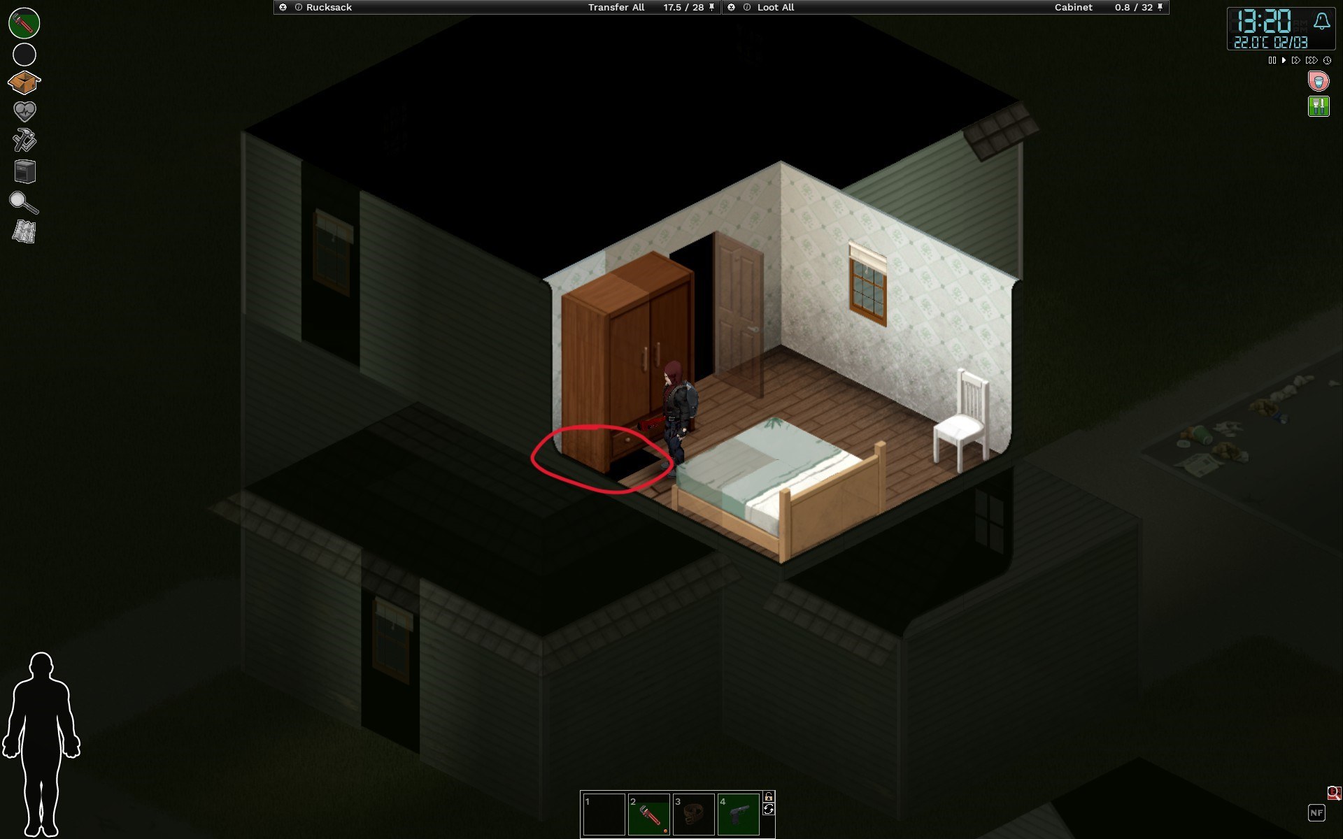
 Coords: 7297x8195 41.78.16 Singleplayer Host No mods Issue persists even on new saves - Texture missing on the floor tile under the wardrobe.
-
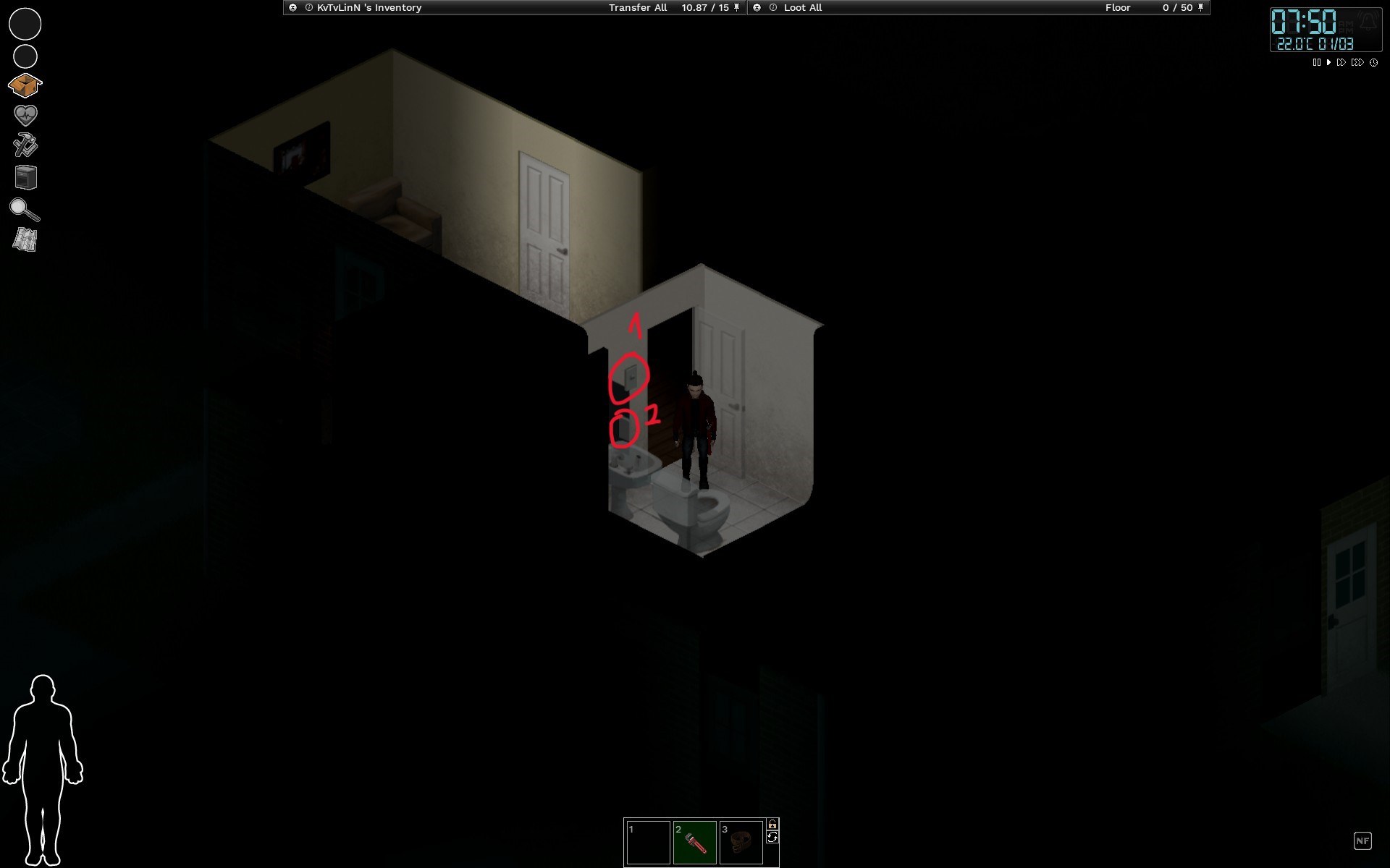
Coords: 7293x8387 • 41.78.16 • Singleplayer. • Host. • No mods. • Still occurs on a new save - The bathroom has 2 lightswitches
-
Marre de l'entraide ? Marre du PVE ? Rejoinds notre serveur FULL PVP ou les RAIDS sont autoriser !!! fraichement wipe ce serveur n'attend plus que toi pour vivre une aventure jamais vu dans project zomboid !!!! n'hésites pas à rejoindre notre discord pour plus d'infos !!!!! Serveur encadré , nombreux EVENT , MOD , CARTES etc !!! venez check c'est par ici : https://discord.gg/F68EzAda7z
-
This house in west point has no light switches inside. https://map.projectzomboid.com/#11490x7053x15701
-
Infinite trees engulf half of the map. The bug manifests with a straight line of trees near Riverside that never ends. It could be a corruption of the map due to some mod, but it could also be just a vanilla malfunction. Images below (link) 1. https://drive.google.com/file/d/11_6aQlyZEAJHl-1trz1Lcmf72nWFCYkv/view?usp=sharing 2. https://drive.google.com/file/d/1s8PgDtb5BJDCEvFuVvle9S01EfB52NWi/view?usp=sharing
-
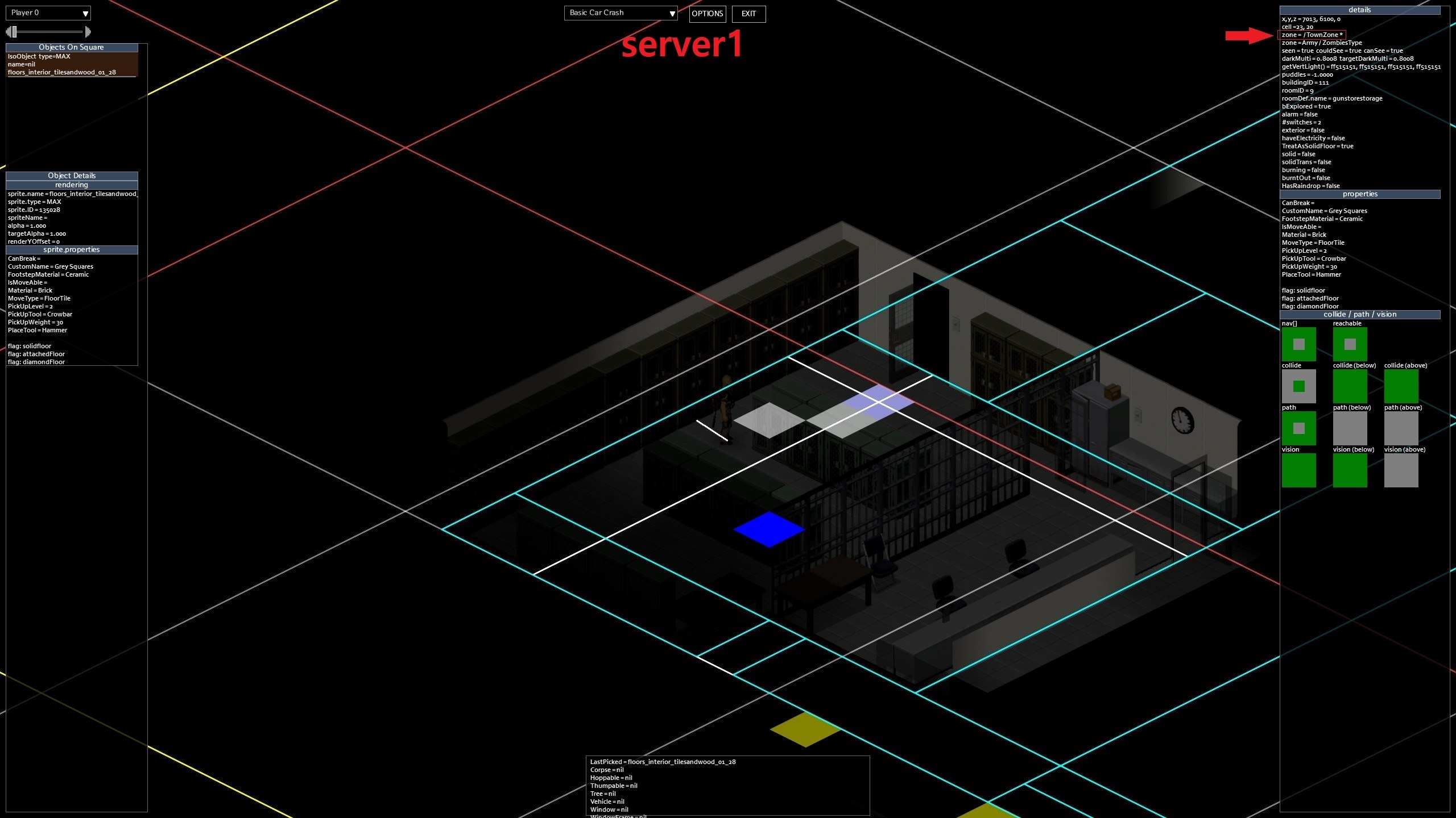
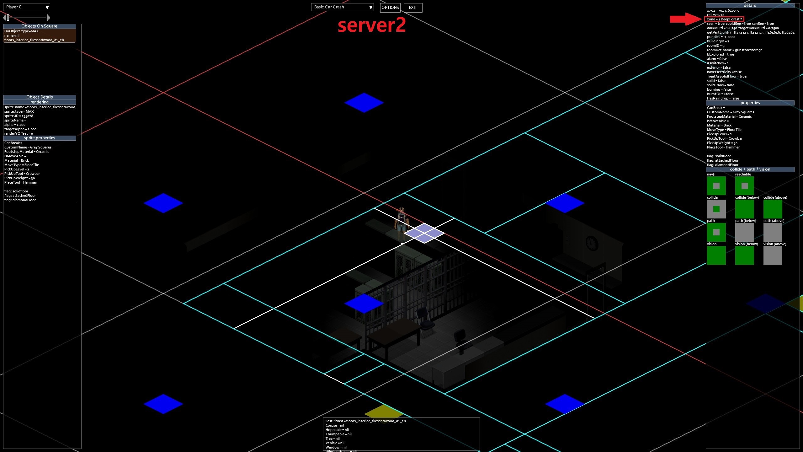
I tried using debug mode because the loot didn't respawn for some time. I noticed that the map's "zone" type was changed to DeepForest. (Only some modmaps seem to have changed. These mode maps are originally set to town.) I don't know the exact cause, but I think that the problem may be that I often used this program. maybe.. not sure https://lordikol.github.io/PZ_MapCleaner/ Is there any way to reset this?
-
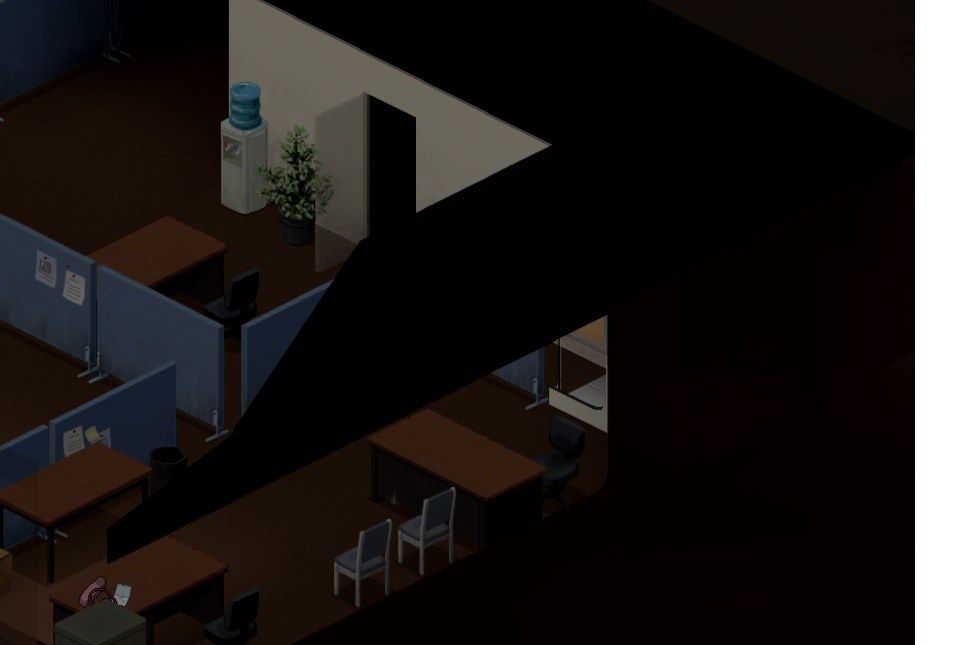
A wall from the roof is displayed inside, blocking player's view: (can't even see my character...) Here: https://map.projectzomboid.com/#12106x2007x5852 Same problem here: https://map.projectzomboid.com/#12106x2007x5852 can't see anything behind those huge tanks
-
ok so from my understanding there are "rooms " that determine the loot that spawns in the containers if this is the case does anyone know where to find a list of all the different names to call the rooms for different loot if this is not the case can someone please explain the way this works and many thanks for any help
-
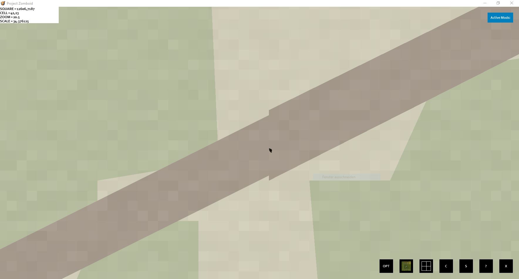
Just stumbled over a small zone error while recreating a road within cell 41,23 The street polygon increases, with the same street width
-
Hello! I would like to create a replica map of my hometown from real life into Project Zomboid. I would like to know what 1 pixel in the game map would be equal to in real life. How many feet/meters is 1 pixel equal to?
-
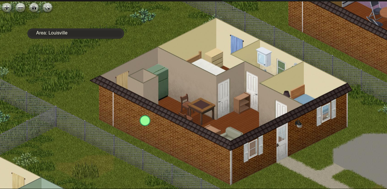
 Version : 41.78.16 (Steam) Player Mode : Singleplayer and MP. Host Or Dedicated : N/A Mods : More map icons (in the screenshots taken.) (Replicated w/o mods.) Reproduction Steps : Location(s) : Multiple areas in Louisville. Problem : Several roads in the Louisville area are not indicated on the map in partiality or entirety. *The roads I indicated are somewhat aggressive in some cases as some start as alleyways but turn into parking lots.
-
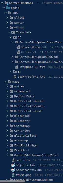
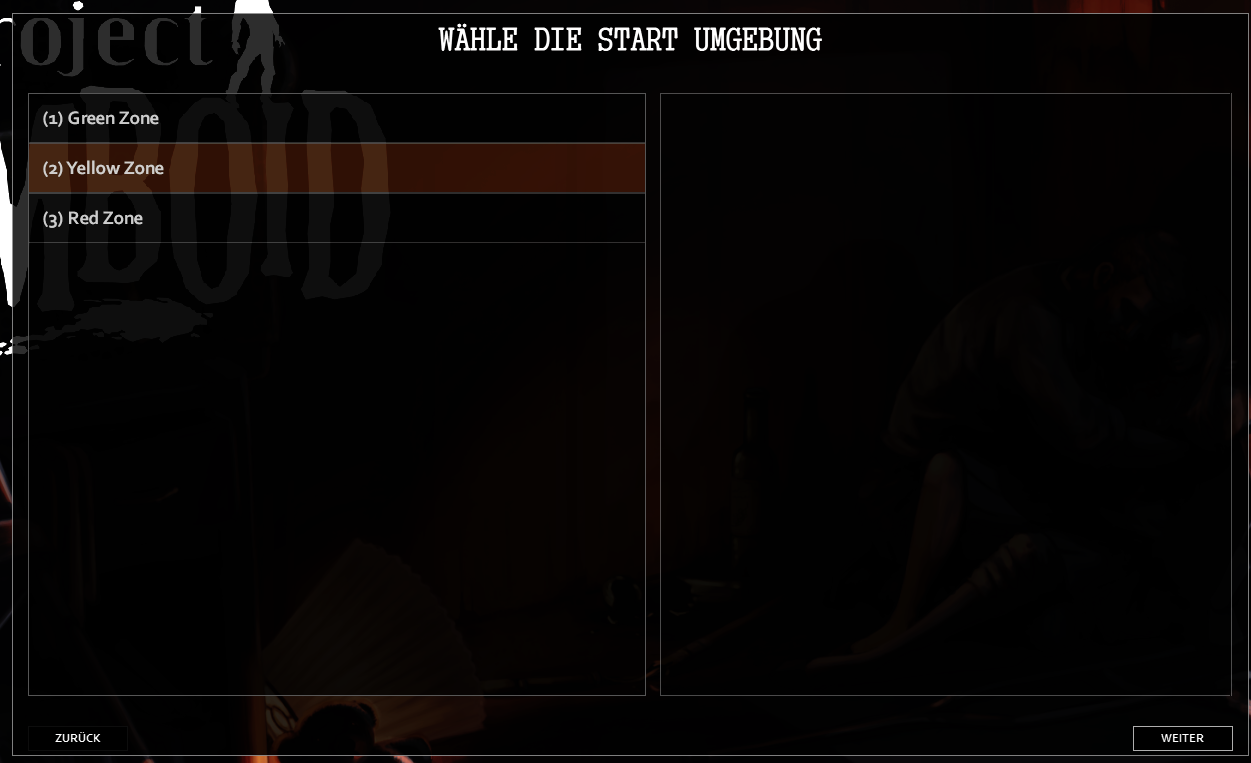
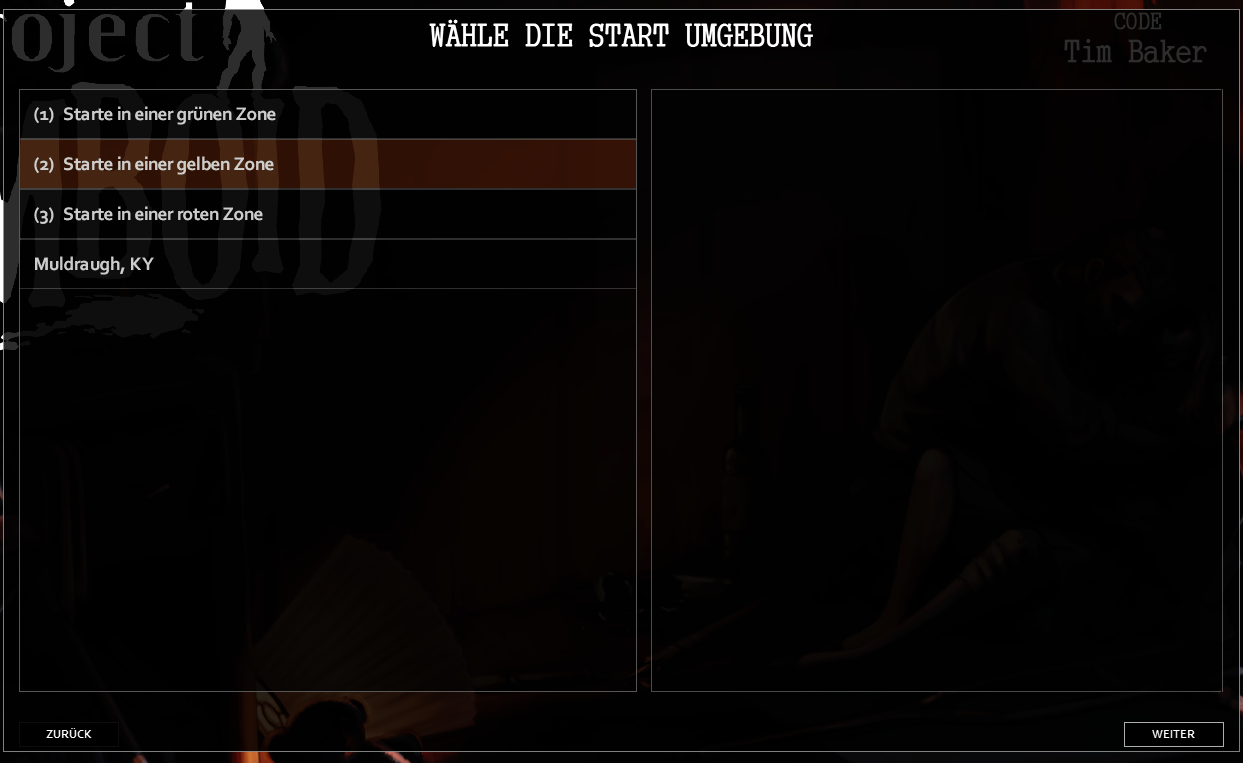
Hi there, I have a map mod with multiple map directories. However, I would like to define my own collection of spawn points as several spawn regions, so I've added three more Map Directories which each represent one of such spawn regions. The spawn regions are displayed and basically works, but neither the description text nor the thumbnail are displayed in multiplayer. But it works fine in single player. I was at least able to translate the titles with a custom solution. But I guess, this should be possible by the core logic itself. This is my folder structure: map.info title=Green Zone lots=Muldraugh, KY description=Initial Description Green Zone fixed2x=true description.txt Übersetzte Beschreibung für grüne Zonen title.txt (1) Starte in einer grünen Zone objects.lua (shortened for better readability) objects = { { name = "", type = "SpawnPoint", x = 10916, y = 10133, z = 0, width = 1, height = 1, properties = { Professions = "all" } }, { name = "", type = "SpawnPoint", x = 10803, y = 10073, z = 0, width = 1, height = 1, properties = { Professions = "all" } }, { name = "", type = "SpawnPoint", x = 10919, y = 10132, z = 0, width = 1, height = 1, properties = { Professions = "all" } }, -- ... } spawnpoints.lua function SpawnPoints() return { unemployed = { { worldX = 36, worldY = 33, posX = 116, posY = 233, posZ = 0 }, { worldX = 36, worldY = 33, posX = 3, posY = 173, posZ = 0 }, { worldX = 36, worldY = 33, posX = 119, posY = 232, posZ = 0 }, } } end DebugServer_spawnregions.lua function SpawnRegions() return { { name = '(1) Green Zone', file = 'media/maps/GartenEdenSpawnsGreenZone/spawnpoints.lua' }, { name = '(2) Yellow Zone', file = 'media/maps/GartenEdenSpawnsYellowZone/spawnpoints.lua' }, { name = '(3) Red Zone', file = 'media/maps/GartenEdenSpawnsRedZone/spawnpoints.lua' } } end Rendered Result: ____________ My workaround to get at least the names translated I've added an file spawnregions.txt to my map mods Translate dir as follows: return { ['EN'] = { GreenZone = '(1) Start in a green zone', YellowZone = '(2) Start in a yellow zone', RedZone = '(3) Start in a red zone', }, ['DE'] = { GreenZone = '(1) Starte in einer gr\195\188nen Zone', YellowZone = '(2) Starte in einer gelben Zone', RedZone = '(3) Starte in einer roten Zone', } } And modified my DebugServer_spawnregions.lua as follows: function SpawnRegions() local activeLang = getCore():getOptionLanguageName() local sGreenZone = '(1) Start in a green zone' local sYellowZone = '(2) Start in a yellow zone' local sRedZone = '(3) Start in a red zone' local translationTable = {} if getActivatedMods():contains('GartenEdenMaps') then local file = getModFileReader('GartenEdenMaps', 'media/lua/shared/Translate/spawnregions.txt', false) if file then local scanline = file:readLine() local content = scanline and '' or 'return {}' while scanline do content = content .. scanline .. '\n' scanline = file:readLine() end file:close() translationTable = loadstring(content)() if translationTable[activeLang] ~= nil then sGreenZone = translationTable[activeLang].GreenZone or sGreenZone sYellowZone = translationTable[activeLang].YellowZone or sYellowZone sRedZone = translationTable[activeLang].RedZone or sRedZone end end end return { { name = 'Muldraugh, KY', file = 'media/maps/Muldraugh, KY/spawnpoints.lua' }, -- just as reference { name = sGreenZone, file = 'media/maps/GartenEdenSpawnsGreenZone/spawnpoints.lua' }, { name = sYellowZone, file = 'media/maps/GartenEdenSpawnsYellowZone/spawnpoints.lua' }, { name = sRedZone, file = 'media/maps/GartenEdenSpawnsRedZone/spawnpoints.lua' } } end So I was able to get this result: In singleplayer it looks like follows: (just borrowed image of bedford to ensure the image file isn't the problem) So what the heck do I wrong? Thanks in advance, stuck1a
-
Hello. Sugestion to put information to "how update interactive map" as a creator it would be nice to have it with other maps in browser. There are many maps rn that are not official but are very detailed and lack proper maping. If there is infromation how to do that i didint found it. https://map.projectzomboid.com/?#9702x5663x10
-
There's no vehicle icon for the mapping function. PLEASE add one! Pretty please with zeds on top.
-
FOLLOW-UP: I've confirmed all of these locations were in the real 1993 Louisville - West Point - Valley Station area except the fireworks store. In a separate post I'll have more generic buildings. 1) The National Weather Service office of far southern suburban Louisville. Its Doppler radar was installed in early 1994 between West Point & Fort Knox. Images of the older radar office + the machinery is here: Radar History at Louisville (weather.gov) In 1993 the office was in southern suburban Louisville, Jefferson County, per April 16, 1998 Poster (weather.gov) - it's just off the highway near where you'd see offramp highway gas stations and basic stores, so it feels more like a rural town than suburban Louisville. - this website includes lots of old posters which you can freely use in PZ; just ask them. 2) GE Appliance Park, in southeastern suburban Louisville. General Electric's Appliance Park in Louisville, KY (Google Maps) (virtualglobetrotting.com) Appliance Park Map.pdf (geappliances.com) It's a vast campus. Half a dozen of the buildings are for production, and the largest is a massive warehouse. It began construction in the 50s and was finished by the 50s or 60s. These factory floors are for making washing machines, dryers, fridges, microwaves, and so forth - so it'd be near-useless to a survivor too, except for scrapping the production lines for goods. You could also use the name of the wholesale kitchen seller already existing in the game's downtown Louisville. 3) The Sheraton Hotel, today known as the Seelbach Hotel. Seelbach Hotel - Wikipedia This luxury hotel is mentioned by name in the Great Gatsby, and Al Capone used one of its back rooms for his dealings, as he had a secret escape door installed in that back room. Numerous secret tunnels and escape routes exist in this hotel. The hotel's been in three movies: The Hustler (1961), The Insider (1999) and The Great Gatsby (2013). The Seelbach Hilton Louisville, KY This link has 3D virtual tours of some of the rooms & meeting rooms in the building: 3D Room & Floor Plans - The Seelbach Hilton Note this hotel is VERY distinct from the already-existing hotel downtown, as this one is truly luxurious. 4) Any of these plaques and/or locations, all found here: https://www.hmdb.org/results.asp?HistMark=Y&WarMem=Y&FilterNOT=&FilterTown=&FilterCounty=jefferson&FilterState=ky&FilterZip=&FilterCountry=&FilterCategory=0&SeriesID=249&Search=Series 5) Phantom Fireworks, in a small town east of Valley Station: Phantom of Louisville South | Phantom Fireworks Numerous photos of the interior are on its website and Yelp Photos for Phantom Fireworks of Louisville - South - Yelp . It just sells lots, and lots, of things that go boom. Given that the soft start date of the Event is July 9th, there'd likely be 4th of July clearance sales of red, white, & blue fireworks on the 9th.
-
I think it'd be really helpful if the markings you've map on the full size map also appeared on the minimap/radar in the lower right hand corner of the screen. That way you could see if you were getting close to important spots you've marked without having to open the full size map which would be more convenient and safe for the player. For example if you mark your house on the map when you're at it and run around trying to make your way back you could see if you're getting closer to it just by looking for the marking on the minimap.
-
How do you add mod maps to an already existing server? We are currently trying to figure out how to add 4 more custom maps to the world and we can't seem to figure out how to get it working. Does anybody have any idea how to get this working?
-
I did a fair amount of modding for TES3: Morrowind, for all you Zoomers out there it was the one before Skyrim and Oblivion, and though dated it continues to have one of the most active and capable modding communities out there. I am part of a still-active project called Tamriel Rebuilt that is systematically expanding the world cell by cell, blending it seamlessly into the original game. Morrowind had an awesome alien world to explore, but it only shipped with a small part of the province playable so there was a shared dream to bring the rest of the world to life. It's really amazing what the TR team has managed to do. It's as if the original developers of the game never quit because we get these incredible expansion packs about once or twice a year from that modding team. Anyway, I live in Louisville, KY so I really got a kick out of Zomboid when I started playing it. But naturally my wanderlust isn't satisfied with the tiny piece of the world we get to play with. The modding community for Zomboid is smaller than TES3 but I thought, what if I could use what I learned from TES3 to lay the groundwork for a similar Zomboid project? I could create a functional basemap, divide it into groups of cells or "claims", and then invite other modders to claim parts of the state for full implementation. It would be the modders' responsibility to blend their work into that of their neighbors for a seamless result. Years down the road who knows, we might be able to explore in ENTIRE state of Kentucky. The freaking castle in Versailles. The capital building in Frankfort. Red River Gorge. Hopkinsville with its alien/goblin folklore. And a slew of bizarre roadside attractions and sleepy small towns, too many to list here. Imagine that kind of world to play in on top of all the features the devs have planned for the final game. So this is something I've been working on quietly for a few weeks now. I have a large photoshop file divided into cells that are sized to match the game world. I pasted in the existing playable area. Then I painted in the rest of the Ohio River and filled in the rest of the state with grass. It's not perfect, but I think I'm getting somewhere. It won't be long before I have a full state map with major roads and cities painted onto the gridmap. Then I can slice them, export them as individual cells, and import into WorldZed. I've run into a few snags. First of all, there are hundreds and hundreds of cells. I need to find some way to automate the slicing/exporting/importing workflow to make it viable. There is also a 100x100 cell limit in WorldZed that might mean I have to work in large chunks. Finally, the top of the game world is at x=0 and I'm not sure yet if you can have cells with a negative x value. I would need to do that to be able to implement any zones to the north of the current area. Does anyone else think there is value in continuing this project? Better yet, does anybody want to help me get this off the ground? Very curious what others in the mapping community have to say.
-
Então pessoal, faz alguns dias que tento criar um mapa, oq eu queria era algo bem simples, só recortar mapas já existentes de mods e colocar num novo mapa (pois quero fazer um servidor RP e n quero q siga sempre a mesma pegada do kentucky. Ja tentei diversos tutoriais de criação de mapas e etc, mas acaba que nenhum é sobre oq eu realmente gostaria de fazer, até gostaria de criar um mapa do zero se fosse o caso, mas acontece que todos os tutoriais que tento (tanto os daqui do forum quanto os de videos) eles sempre dão um erro onde n acho o problema, como a imagem n ir pro programa, ou o programa n reconhecer o mapa após eu ja ter salvo ele no WorldEd.
-
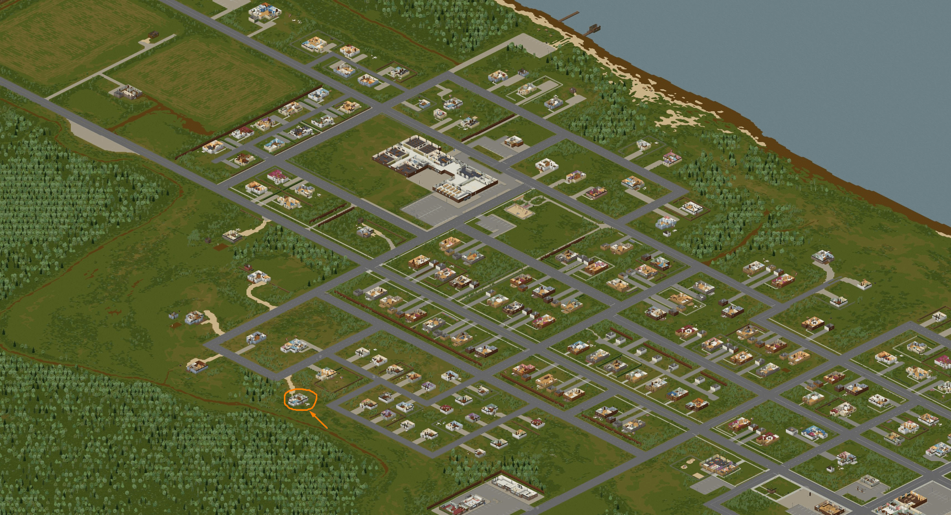
 The unnamed town I'm referring to is here on the map project. It's been referred to by many names over the years, and I believe the most popular has been Ekron. For awhile the map project also had waypoints that referred to the area as Dixie, which is actually the area north if you follow the road out of Muldraugh to the trailer park. However, as noted in this post here, the actual town of Ekron is being developed and the town being discussed, as TheZedSurvivor pointed out in his video, is the location the 'unnamed town' refers to is an area called Lickskillet. By not naming the town, it has actually made referencing the area more confusing than it needs to be. Since there have been so many names attributed to the area in game over the years, I think at least one in game sign to give the town a name would do a lot of good in clearing up the confusion. Whether it gets the real life name of lickskillet, or a made up one, either way a name in game will make it a lot easier to call out this area when referencing the map. It may be a minor thing, but the unnamed town is a hotspot for players due to its location and useful stores and since it never had a name we could find in game, it meant players did their best to give it one. Even if the town in real life doesn't have a sign, for game purposes it would add a lot of value. It may be a weird suggestion, as far as priorities are concerned, but after years of seeing posts that give this town every incorrect name under the sun, it'd be good to have a single point of reference that finally gives this town a proper name.
 -
It is posible to move zombie spawning, ground floor lvl and growing trees from layer 0 to layer 2? That operation will give us 2 free layers that we can use to mod sewers/basments/bunkers etc. If it is posible to do that adding only 2 leyers will be great then we will not need to move every tree on diffrent leyer manualy.
-
Good day survivors! While I love the new map additions with b41 stable, I've come to find the power lines along long stretches of road to be a bit of a distracting feature. I'll show a couple of examples to what I mean: While from the perspective of the camera the lines would look like this, the lines create this distracting illusion of being lines laid along the road, not up in the air due to the isometric perspective. I'd like to propose that the power lines near the character fade away in a similar fashion to the tree I'm standing next to when they're close to me. The fade away would keep the lines being directly atop the character which I've come to find a bit distracting and doesn't look as good. I've only got a small sample size of people I've asked about how the power lines look along roads like this and had a couple in agreement, so I'd thought it make for an interesting discussion if other people get that optical illusion of the lines being on the road. To check that I've got a little video clip below I took of driving along the power lines. driving along the road shown below: https://i.imgur.com/j93g6zi.mp4 Not all roads are like this, some have the power lines in an orientation that has them off the road and they look amazing driving out in the country and look that much more realistic and beautiful. The road in this video look a lot better, to me anyways. https://i.imgur.com/1ni5EXP.mp4 What are your thoughts? Do you think a fade-away option similar to trees would help with this or make it look better, or do you believe it's fine from the camera's perspective versus the player's perspective?


.png.e678f7014009480139348a1455c61c67.png)
.png.9b7611aeec512543db60ea5c93b5c2bd.png)
.png.1fe1c303b8a2622e91b683bda4b91361.png)
.png.8c847c180909fdfe5286a082d664ca84.png)