Oppolla
-
Posts
8 -
Joined
-
Last visited
Everything posted by Oppolla
-
Are you searching in Tile mode?
-
sorry
-
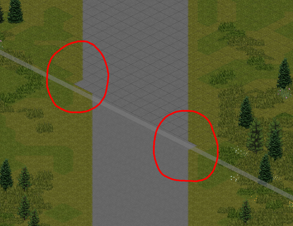
I having an issue where roads at the edge of a cell have a "nub" at the end that I can't seem to get rid of. I think it's a blending issue. Does anyone know how to resolve this?

-
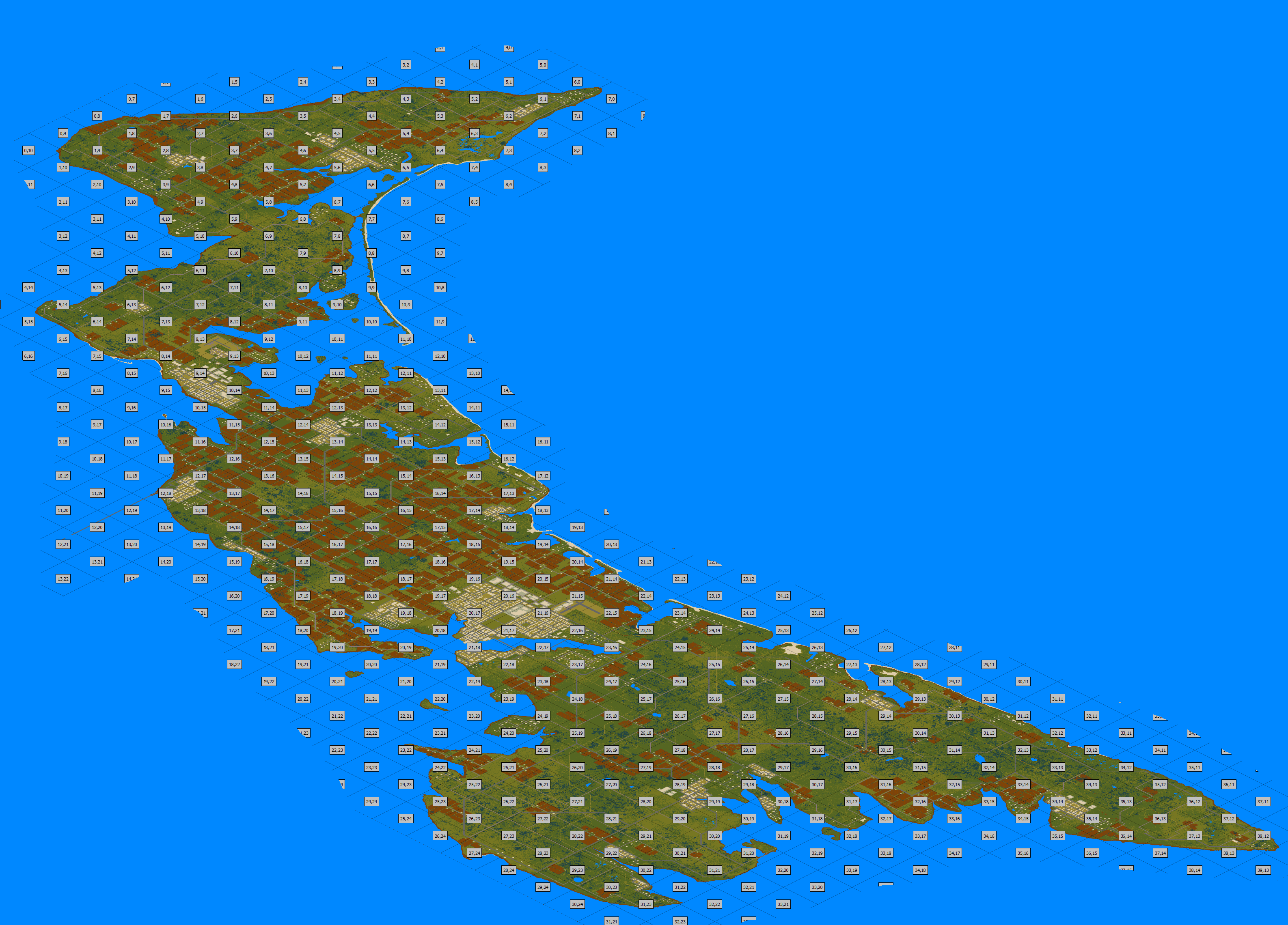
Here are what the raw cells look like to get an idea of the work that still needs to be done. If any cell interests you, reach out and I'll send it over. Right now, I'm starting from the east end of the island and working my way westward.
-
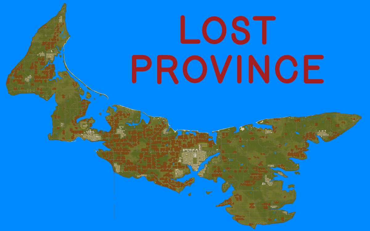
Lost Province About the project: Hello all! This is a custom map project I've been working on in my free time for a few months now. It's a 40x25 cell completely custom map roughly recreating the province of Prince Edward Island in Canada. There are several ideas behind this project. Firstly, I wanted a map that was self contained that didn't have any invisible walls; a map with natural boundaries but also large enough that you could have a full nomadic experience on. An island felt like a natural choice. After searching the world for islands, I went with PEI. The second aspect I wanted to focus on with this map is the road system. One of my favourite aspects of PZ is doing road trips with friends. This game captures that feeling better than any other. With this map, I wanted something that resembled road systems in the real world. I adapted the actual highway and road system of PEI so the relations between highways, side roads, city roads, are all true to the real world. The roads connect the major urban centres, side roads lead to smaller rural communities, other roads lead to cottage country and resorts. I put a lot of thought into the logic of the road system, which hopefully makes navigating it feel more real. This is going to be a big map. Not as big as Kentucky, but still pretty big. I tried to keep the scale of the world in line with the official map. The length of the island is about the distance between Riverside and Louisville, but the roads a bend and wind so the actual distance will feel longer. The main town is Charlottetown in the middle. It will be roughly Muldraugh sized, but denser. To the west is the second largest town, Summerside. There are also smaller settlements throughout. This is still really early. I'm in the process of building out rural areas on cell at a time. For the rural areas, it's 5-10 houses per cell that need building, as well as cleaning up some blends, adding curbs to roads, and general detailing. If you've been wanting a map like this and you're interested in helping, feel free to reach out. Any help would really speed up development.
-

Latest TileZed, WorldEd and Tilesets (September 8 2022)
Oppolla replied to EasyPickins's topic in Mapping
I'm getting that BuildingFurniture.txt error. What files do I need to delete in C:\Users\XXX\.TileZed.? I tried deleting everything and PZWorldEd gets an error while opening. -
Before I run any bitmap image through PZWorldEd, I convert the colour mode of the file to Indexed in Photoshop. I created a palette that only has the legal colours so when the image is converted to Indexed Colour Mode, any stray colours are converted to one of the legal colours. It's a quick, easy way to know for sure you don't have any colours that aren't supposed to be there.